A corridor only about twenty kilometres wide at its narrowest
Open a map of India and you see an odd shape, as if someone drawing it had been jostled halfway: north of Bangladesh there is a stretch of land running east to west, joined to the main body of India by only a very narrow corridor.
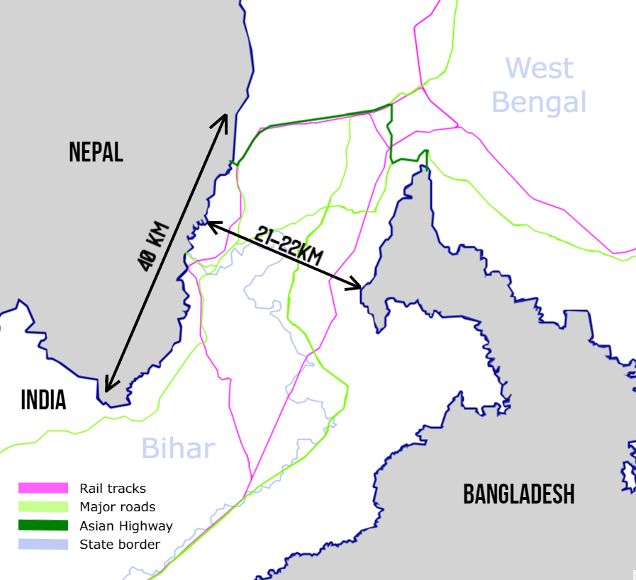
Sketch of the Siliguri Corridor ("Chicken's Neck"): the seven northeastern states are joined to mainland India by this strip, in places only about twenty kilometres wide. Source: Wikimedia Commons, see CREDITS, CC BY-SA 4.0

This corridor is called the Siliguri Corridor, inside the state of West Bengal, about 60 kilometres long and, at its narrowest, about 17 to 22 kilometres (sources do not agree exactly). To its west is Nepal, to its north Bhutan, to its south Bangladesh, and a little further northeast, across Bhutan, is China's Yadong (Chumbi Valley). Indians gave it a nickname, the "Chicken's Neck."
At the other end of the Chicken's Neck lies the northeast: Assam, Arunachal Pradesh, Manipur, Meghalaya, Mizoram, Nagaland and Tripura, seven states, sometimes called in Chinese the "seven northeastern states" and by Indians themselves the "Seven Sisters." With Sikkim, which joined the North Eastern Council in 2002, the official "northeast" is eight states. The name "Seven Sisters" was coined off the cuff by a Tripura journalist on a radio programme in January 1972, when Meghalaya, Manipur and Tripura became states at the same time, and it spread.
Together they hold only about 3.8% of the national population (2011 census, about 45.77 million, counting the eight states).
A "familiar" name, an unfamiliar place
You may not find this region unfamiliar: Assam tea, the woman boxer Mary Kom, football-mad Mizoram, "organic state" Sikkim. But ask an ordinary urban Indian whether he can name the seven states, and many could not. He knows the tea but not necessarily where it grows. That is also what "most familiar strangers" in the title means.
The people here differ from "mainland India" in many ways:
- Ethnic groups and languages. The usual claim is that the northeast has over two hundred ethnic groups (counts differ), speaking languages of different families such as Tibeto-Burman, Mon-Khmer and Tai-Assamese. Many look closer to Southeast or East Asians.
- Religion. In the 2011 census, Nagaland and Mizoram were each nearly ninety percent Christian, Meghalaya 74.6%, and Manipur over forty percent; Baptist and other missionaries came here in the late nineteenth century. Arunachal has about 30% Christians and about 12% Buddhists, and Sikkim nearly 30% Buddhists, mostly Tibetan.
- Social customs. The Khasi of Meghalaya are matrilineal: property passes to the youngest daughter. (Mentioned in the piece on why it is so hard to be a woman in India.)
One addition: the northeast is not uniform inside. The plains of Assam, the valley of Manipur (the Meitei) and Tripura have many Hindus; Assam also has about a third Muslims; and many tribal groups in the hills have neither caste structure nor Hinduism. So "northeasterners" are not one whole, and saying they are "different" from mainland India depends on which part. Calling eight states one word is an administrative convenience to begin with.
Why it is so: a few threads
One, historically not quite part of "India." Assam, for example, was ruled for about six hundred years from 1228 by the Ahom dynasty, which the Mughal empire's several attacks failed to take. The British obtained Assam from Burma through the Treaty of Yandabo in February 1826 and began growing tea. Most of the other states were managed by the British as "frontier areas," in many places through missionaries and police rather than formal administration.
Two, integration after independence. When India became independent in 1947 these regions were folded into the new state, but many groups did not identify with it. The Nagas took up arms from the 1950s; the Mizos rose in 1966 and became a full state in February 1987 only after the 1986 peace accord. The armed groups of the region, taken together, have not disappeared for decades.
Three, the border. In 1962 China and India fought a border war here. China calls most of Arunachal Pradesh "South Tibet," claiming about 90,000 square kilometres; India says it is its own territory, and Arunachal's area is 83,700 square kilometres. The two sides' disagreement partly cannot avoid the McMahon Line drawn at the Simla Conference of 1914: India accepts it, China does not. The border dispute here has no conclusion to this day.
Four, shut off. The 1947 partition of India and Pakistan had East Pakistan (later Bangladesh) cut most of the overland routes between the northeast and mainland India, leaving only the Chicken's Neck. The northeast's trade and transport were "locked" for decades, and to this day much cargo has to take a long detour to reach the port of Kolkata.
Special laws and violence
The Armed Forces (Special Powers) Act (AFSPA, 1958). A law giving the army special powers in "disturbed areas": under certain conditions to shoot, arrest and search, and prosecuting soldiers needs the Centre's approval. It has been applied for long periods in parts of the northeast, accused of causing many human rights violations and held by the army to be necessary. It was fully withdrawn in Tripura in 2015 and Meghalaya in 2018; in 2025 the Centre still extended it to most of Manipur (except 13 police station areas in the valley), Nagaland and parts of Arunachal, six months at a time.
This law has left two names in the northeast that many Indians know.
One is Irom Sharmila. On 2 November 2000, at a bus stop in Malom, Manipur, the Assam Rifles opened fire and killed 10 civilians, including children. A few days later this twenty-eight-year-old woman began a hunger strike demanding the repeal of AFSPA. The government put her in a hospital on a charge of "attempted suicide" and force-fed her through a tube in the nose, for sixteen years. On 9 August 2016 she licked a drop of honey, declared an end to her fast, and turned to standing for election. The law, she did not manage to have repealed.
The other is Thangjam Manorama. In July 2004, the 32-year-old was taken from her home by the Assam Rifles, and the next day her body was found in a field. The troops said she was a member of an armed group, shot dead while fleeing; a judicial inquiry report made public ten years later said she had suffered "cruel and merciless torture," and it is widely believed that she was raped. A few days later a dozen middle-aged Manipuri mothers stripped naked at the gate of the Kangla Fort in Imphal and held a banner: "Indian Army, rape us." (The number and the date differ slightly between sources; most say mid-July.)
These two events say more than any statistics about why many northeasterners feel theirs is a place "governed," not "their own country."
Assam's National Register of Citizens (NRC). On 31 August 2019 Assam published its final register of citizens to find illegal immigrants (mainly from Bangladesh); of about 3.11 crore (31 million) applicants, more than 19 lakh (about 1.9 million) were left off. Those excluded can appeal to Foreigners Tribunals. The matter was then entangled with the Citizenship Amendment Act (CAA).
Manipur. This is the heaviest example of recent years. In May 2023 large-scale conflict broke out between the Meitei (living mainly in the valley) and the Kuki-Zo (living mainly in the hills); one direct spark was the dispute over giving the Meitei "Scheduled Tribe" status. By 2025 over 260 people had died and over 60,000 were displaced (HRW's figures); the state government said in the state assembly in September 2026 that from May 2023 to 31 August 2026, 306 people had died and 49 were missing, and the two communities were almost separated geographically. On 9 February 2025 Chief Minister Biren Singh resigned, and on 13 February the Centre announced President's Rule (direct takeover by the Centre). On 4 February 2026 President's Rule was lifted, and the NDA's Y. Khemchand Singh was sworn in as Chief Minister, with a Kuki former minister, Nemcha Kipgen, as Deputy Chief Minister.
The news heat of these events nationally is not in proportion to their seriousness. That too is part of "unfamiliar."
Strangers in "familiar places": racial discrimination
One more thing connects to the title. Northeasterners in the big cities of mainland India are often treated as "foreigners": looking different, called "Chinese," even given insulting nicknames. In January 2014 Nido Tania, a 20-year-old student from Arunachal Pradesh, was mocked by shopkeepers at the Lajpat Nagar market in Delhi over his hair and looks, a quarrel broke out, he was badly beaten and died, setting off protests; in the early days of Covid in 2020, northeasterners were again shouted at as "Corona" and "Chinese," spat on and refused entry into housing colonies, and the Home Ministry issued a notice asking states to deal with such harassment.
After the Nido case a special committee (the Bezbaruah Committee) was set up and handed in its report in July 2014; its most often cited demand was to make racial insults such as "momo," "chinki" and "Chinese" themselves illegal. But exclusion in daily life is hard to solve with one law.
Why it suddenly matters now
In recent years the northeast has been placed again at the centre of Indian strategy, for two main reasons.
One, the "Act East" policy. India wants more trade and diplomacy with Southeast Asia, and the northeast is its natural gateway. Roads, bridges, tunnels and railways here have been built faster in recent years; for instance the Sela Tunnel, opened on 9 March 2024 in Arunachal at an altitude of about 13,000 feet, so that the road to Tawang can be used all year by military and civilians alike.
Two, security. The "Chicken's Neck" is too narrow. If India used to worry about its South Asian neighbours, it now has to add China to the north and the uncertainty after the change of government in Bangladesh in 2024. All this makes "how the northeast connects to mainland India and to Southeast Asia" a real problem.
Turning it around
The claim that "the northeast is a neglected place" also needs a few additions.
First, the word "northeast" itself flattens differences. Mizoram has for many years been a relatively calm state with a high literacy rate; Sikkim is rich and stable; Manipur's and Nagaland's problems are completely different. They do not even share a language; to put them together is already a simplification.
Second, the central government tells it differently. India's Home Ministry has consistently claimed that violent incidents in the northeast fell markedly after 2014: 824 in 2014, 243 in 2023, down about 71%; several peace accords were signed in the period (the Bodo accord of January 2020, the Karbi accord of September 2021, the December 2023 accord with the pro-talks faction of the United Liberation Front of Assam). The claim has some force, but from the same official figures, 187 of the 243 incidents in 2023 were in Manipur, and 203 of the 266 in 2024 (to November), so a statement like "the northeast is already stable" is hard to sustain.
Third, locals do not agree about "integration" either. Some want more autonomy; some feel that becoming Indian has given them better education and more jobs; some do not want to be reduced to either side.
If a country's border regions are important to its geography and strategy but strange to most of its people, how should that country make its citizens truly "know" these places?
References
- Siliguri Corridor: Wikipedia "Siliguri Corridor" and Drishti IAS, Geopolitical Monitor and others (about 60 km long, narrowest 17–22 km)
- Armed Forces (Special Powers) Act, 1958 and reports of the extensions of April and September 2025 (News On Air, Morung Express, The Hitavada); withdrawal in Tripura in 2015 and Meghalaya in 2018 (Assam Tribune and others)
- Northeast population: 2011 census, eight states together 45,772,188, about 3.79% of the country; religion: 2011 census and Pew, Religious Demography of Indian States and Territories (2021)
- The term "Seven Sisters" and Sikkim's joining the North Eastern Council in 2002: Wikipedia "North Eastern Council," Assam Tribune and others
- Ahom dynasty 1228–1826, Treaty of Yandabo 24 February 1826; Mizo Accord 1986, statehood 20 February 1987
- Sino-Indian border: Wikipedia "Sino-Indian border dispute" (China's claim in the east about 90,000 sq km); Bloomberg April 2023 report (the Indian government's response)
- The Nido Tania case and the Bezbaruah Committee (July 2014): Wikipedia "Murder of Nido Taniam," The Wire; the Home Ministry's 2020 notice on harassment of northeasterners (Deccan Herald, Quint)
- Home Ministry statistics on violence in the northeast and peace accords: Eastern Mirror 2024, Morung Express, Deccan Herald; accord dates in the Home Ministry's northeast peace process documents
- Assam NRC final list of 31 August 2019 (Business Today, Scroll, LiveLaw); Sela Tunnel opened 9 March 2024
- Manipur conflict: Wikipedia "2023–2026 Manipur conflict"; Human Rights Watch, India: Ethnic Clashes Restart in Manipur, March 2025; International Crisis Group report
- The Indian government's account of the "Act East" policy (indbiz.gov.in and others); IDSA analysis of the northeast's place in Act East
- Reports on the Assam NRC (August 2019)
- India's 2011 census (population of the eight northeastern states)
- Irom Sharmila and the Malom incident: Christian Science Monitor (2016-07-27), Mainstream Weekly, Frontline; the Manorama case and the 2004 Kangla protest: Deccan Herald and others 🟡